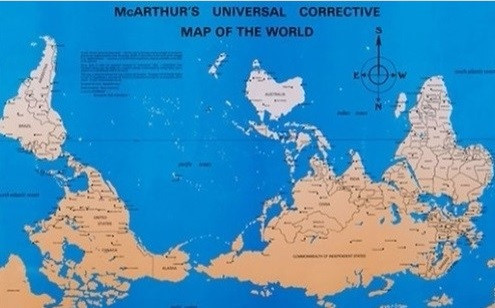
Why are Northern Oriented Maps and Globes Still the Norm in Geography?
The images of the Earth from Apollo 17 and others from space have all proven ot indisputable that in space, we have no notion of up or north or south. Joaquín Torres García back in 1900 produced an early Southern oriented map which was seen as a political act in that it showed Latin America from a completely different perspective. The northern biased in mapmaking continues the prejudice towards those countries that are either partially or entirely south of the Equator. North is considered up or closer to heaven and South down and closer to hell. Wealthy Europe is looked upon as the center of a greater globe. This is entirely unsupported by its actual land mass or population makeup.
Why have we not outgrown this? Taking a look at a southern oriented map gives you an entirely different perspective on this planet.
 7
7


Enjoy being online again!
Welcome to the community of good people who base their values on evidence and appreciate civil discourse - the social network you will enjoy.Create your free account
13 comments
Feel free to reply to any comment by clicking the "Reply" button.

How it began and what made it what it is doesn't matter anymore. The argument over north or south orientation was something for the time, but has no place today. It is now a standard that could be changed if deemed necessary or advantageous, but neither of those apply. None of the north poles of the planets or sun are aligned with our north pole. The closest is Mars. Why did we choose h-bar for Planck length and not p-bar? Why is "up" what it is? A bigger and certainly more important issue is why is the US still not using the metric system?
 evidentialist
Level 8
Mar 13, 2018
4
evidentialist
Level 8
Mar 13, 2018
4
Because we can’t seem to do ANYTHING as a country anymore?? Our partisan divide is too strong? And it doesn’t bode well do you think? I’m 63 and as a child we were always told we were going to change to the metric system. What happened?
No matter what maps i look at, my house is always hidden by the large trees around my property.
 Spinliesel
Level 9
Mar 13, 2018
3
Spinliesel
Level 9
Mar 13, 2018
3


We still use religion as our way of keeping time. remember we are by far the minority.
 LeighShelton
Level 8
Mar 13, 2018
2
LeighShelton
Level 8
Mar 13, 2018
2
Why do I get a sinking feeling when I look at that map?
I suspect it has a lot to do with the European prespective of the world at the time that modern catography was beening developed and much of the South was still a mystery.
 HeathenFarmer
Level 8
Mar 13, 2018
3
HeathenFarmer
Level 8
Mar 13, 2018
3


It's not just that. Mercator projection maps distort the hell out of the sizes of land in areas near thepoles, especially the north where there is more landmass. Greenland is usually shown as being as big or bigger than S. America or Africa, & it is not really close. There is a lot of debate about maps (they even had a large bit of a "West Wing" episode on this), orientation is just one facet.
 phxbillcee
Level 10
Mar 13, 2018
5
phxbillcee
Level 10
Mar 13, 2018
5

Enjoy being online again!
Welcome to the community of good people who base their values on evidence and appreciate civil discourse - the social network you will enjoy.Create your free account
Share this post
Categories
Agnostic does not evaluate or guarantee the accuracy of any content. Read full disclaimer.