Have you been lost in the woods?
"Before we left Des Moines I had tried to learn how to use a compass, but it was like teaching superstring theory to a goldfish," John Rika wrote in his hilarious book, "Rookies in the Wild- Fear and gloaming on the Pacific Crest Trail."
We both got confused reading about declination: setting your compass for True North as opposed to Magnetic North. It was so complicated, I gave up. Every hiking book says you must always carry a map and compass.
For forty years, my untouched compass rode in the bottom of my packs. Fell in love with Green Trails Maps. Waterproof, topographic, colorful and detailed, these maps show trail crossing, streams, creeks, lakes, peaks, distance between points, elevation and more.
Since I'm directionally-impaired, it helps if my hiking partner has a good sense of direction.
Dan and I got a bit lost on Pacific Crest Trail, WA. We couldn't find Hope Lake with the wooden sign that points to our cars. We stopped and assessed the situation:
-
Three hours of daylight left.
-
With what we had in our packs, we could spend the night in the mountains.
-
We could bushwhack (always a bad idea) down to U.S-2, hitchhike to the gravel road, and walk over four miles up the logging road to our cars. With our headlamps.
Dan kindly gave me an impromptu lesson on using a compass and map. It finally made sense. We walked back-and-forth on the Pacific Crest Trail- two miles north and south-expanding our search. Where was Hope Lake?
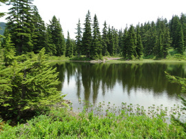
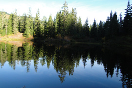
Lakes all looked the same
"I'm going to send a sternly-worded letter to Green Trails Maps," Dan said dryly. Three lakes beside the trail were not on the map. The lakes looked identical. Deer trails radiated out from the lakes like spokes on a wheel.
Here comes Sue, 54, hiking alone with a solar-powered GPS on her hat. Sue was section-hiking the Pacific Crest Trail. Her daughter hiked the first ninety miles with her.
"Do you know where Hope Lake is?" I asked. "Turn around and Hope Lake is a half-mile south this way," she replied. We were going the wrong way.
"Can we walk with you to Hope Lake, please?" I asked. Yes. My hero! Love Sue. When we arrived at Hope Lake, I hugged the wooden trail sign and kissed it.
Next was a wickedly steep descent in failing light. I tripped on a rock and fell. Then I put on my headlamp.
Dan was on of my favorite hiking partners until he moved to Utah. I miss him.


Enjoy being online again!
Welcome to the community of good people who base their values on evidence and appreciate civil discourse - the social network you will enjoy.Create your free account
14 comments
Feel free to reply to any comment by clicking the "Reply" button.I am partially blind, but when I still lived in Portland (OR), I'd join various hiking groups for day hikes. I'd sometimes hike the parks and hill trails in the middle of Portland, which seem like you are hiking in forests, until you spot a house hidden in the trees up a hill, or the trrail comes out temporary on a road. My favorite was the 4-T trail. I'd start at Washington Park and end up at OHSU.
Back before I started losing vision, I always had a pretty good sense of dirction. Even after I started to lose vision, some friends who had no sense of direction would come get me to go with them, because I wouldn't get lost. I was one of those annoying people who could just look at the position of the sun, and be able to know directions and generally what time it was. Not so good as I once was though.
I'd still be hiking except I got priced out of my apartment in Portland and so I moved in with my sister in Battle Ground (WA), and public transit out this far isn't good enough to get me to the meeting point(s) (in Portland) of the hiking groups early enough to join them.
For persons who have no sense of direction, I's suggest getting a GPS, or at least downloading an dlearniogn how to use a compass app for your phone.
I'm sorry about your failing vision. Proud of you for hiking and helping people.
Men love gadgets. Often there is no cell phone coverage in the mountains.
GPS units require you to upload expensive maps that are inaccurate. Many lakes and trails are not on GPS maps. They eat batteries for lunch.
It is unsafe to look down at a GPS following a little arrow. You must watch your step. Trails are rocky and steep.
Nobody I know brings a GPS. Experienced hikers carry maps.
A former boyfriend gave me a GPS for my birthday. A rookie, he had never hiked before meeting me. I was deeply disappointed with it. Sold it to a fisherman.
@LiterateHiker Yes, some GPS's are not as good as others. I don't use one myself. However I think it might be good for a person in the hiking group to have one. If I had one, I'd keep it turned off and packed, unless it was actually needed. Then only consult it once in a while, keepign it turned off most of the time to save battery life.
I keep wondering how long until a cell phone is able to use satellites to make calls, and there are no dead areas as long as you have access to open sky.
You should get your pictures published in a nature magazine.
Thanks, but I don't want to attract hoards of hikers to my favorite hiking areas. Crowds ruin the experience.
For this reason, I no longer post hiking pictures on Facebook.
I used to go on archaeological surveys in Rocky Mountain National Park. And the Park rangers told us that if we ever got lost, just walk downhill. Sooner or later, you come to a trail, a road, a train track, or a stream that will take you back to " civilization".
I would never bushwack without a map. That's a quick way to get hurt.
It's not lost, it's temporarily geographically embarrassed. Compasses are old tech. Ditch it and get a gps or use google maps on your phone.
Men love gadgets. I can tell you don't hike in Washington State. Often there is no cell phone coverage in the mountains.
GPS units require you to upload expensive maps that are inaccurate. Many lakes and trails are not on GPS maps. They eat batteries for lunch.
It is unsafe to look down at a GPS following a little arrow. You must watch your step. Trails are rocky and steep.
Nobody I know brings a GPS. Experienced hikers carry maps.
A former boyfriend- an inexperienced hiker- gave me a GPS for my birthday. I was deeply disappointed with it. Sold it to a fisherman.
@LiterateHiker considering I'm about 12000 miles from you, no I haven't walked in those mountains. I do go on treks in rough mountainous country that last weeks at a time so I have high quality gear. A gps does not rely on cell phone coverage and the one I use is the size of my watch and will run for a week without a recharge. It does not rely on expensive uploaded maps but has inbuilt geographical data and will also just plot a track so you can see where you are relative to the start or where you've walked. It also provides grid references that I can translate to map coordinates. I've an app on my phone which will do that if I just want a day walk. It's called Mgrs and UTM map. No cell coverage required, just mobile and map. I don't know what you were given but you shouldn't judge state of the art equipment by something that someone just gave you. And noone here looks at his gps, watch, compass or mobile while walking in country where your next step could be on a deadly snake. It is normal to stop while you work out where you're going. You don't follow the little arrow, even on your compass, but pick an object on your bearing and walk towards that. I carry map and compass as well and I'm damn certain I can use them better than most because it's all I had for 20 years of walking in untracked country but these days they just provide backup.
I love your stories and you always have nice pictures. All I know about hiking is watch the sides of the trees to tell which way is East. If I use a compass it is to site in exact co-ordinance for setting up a TV antenna or satellite dish.
Thank you so much!
I was a Boy Scout and I can navigate by compass.
I was also inducted into The Order Of The Arrow, and that required (among other things) being taken out in the wilderness, blindfolded, with nothing but a tarp, water, and a compass. Alone. And had to find my way back to the campsite. In unfamiliar territory (Pennsylvania). No problem.
Stunning pics. Poor health keeps me from hiking these days, but even when I was well I was what I called "slow and steady" but the people who passed me called me "dead wood".
Thank you. Sorry you have poor health.
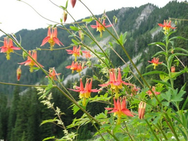
red lantern columbine! Just moved out of a rental house that had a ton, then the owners removed them all after we left. :::
When I sold a house a couple of years ago the new owner ripped out some beautiful lilacs. I know, I know, they blocked the view of on coming traffic from the driveway, but they were beautiful.
I've hiked a few of the 100 peaks in California.
Have been a little lost, as I didn't understand the compass either.
The serenity found is worth the effort.
I don't think we carried a compass or map when we hiked, but we always stayed on well marked trails. I equipped the kids with a fanny pack with a whistle, a mirror, and a large plastic garbage bag cut to be a poncho, some sort of granola bar, and a water bottle. IF they got lost they were to hug a tree, blow the whistle, and reflect the sunlight off the mirror. If it rained they had the poncho, and they had some food and water. We never had to test it, they were good about staying on the trail where we could see them.
What's the mirror for?
The chance of signaling a helicopter is a slim to none. Especially in the woods.
@LiterateHiker it's been quite a few years (the youngest just turned 30 today and we moved to Kansas when she was 7.) I think it was just so they could be more easily spotted. We weren't usually in heavy woods, the assumption being anything to increase visibility.
Enjoy being online again!
Welcome to the community of good people who base their values on evidence and appreciate civil discourse - the social network you will enjoy.Create your free account
Share this post
Categories
Agnostic does not evaluate or guarantee the accuracy of any content. Read full disclaimer.


