We were lost on the Pacific Crest Trail.
"Before we left Des Moines I had tried to learn how to use a compass, but it was like teaching superstring theory to a goldfish," John Rika wrote in his hilarious book, Rookies in the Wild- Fear and Gloaming on the Pacific Crest Trail.
We both got screwed reading about declination: setting your compass for true north, as opposed to magnetic north. It was so complicated I gave up. Every hiking book says you must always carry a map and compass.
So, my untouched compass rode in the bottom of my pack for 40 years. I fell in love with Green Trails maps. Waterproof, topographic, colorful and detailed, these maps show every trail crossing, stream, high point, elevation and more.
It helps to hike with someone with a great sense of direction. I'm directionally-impaired. Karen, my favorite hiking partner, has a compass embedded in her brain.
In 2015, Dan and I got a bit lost on the Pacific Crest Trail. We couldn't find Hope Lake with the wooden sign for the trail that leads to our cars. We stopped and assessed our situation:
- Three hours of daylight left.
- We could spend the night with what we had in our day packs. I always carry a light down jacket, raincoat, reflective survival blanket, water purifier, headlamp and first aid kit.
- We could bushwhack (terrible idea) down to Highway 2, hitchhike (bad idea) to the gravel road, and walk some 2-3 miles up the gravel road to our cars with our headlamps.
Dan kindly gave me an impromptu lesson on using a compass and map. It finally made sense. We walked back-and-forth on the PCT- two miles north and south- expanding our search. Where was Hope Lake?
"I'm going to send a sternly-worded letter to Green Trails maps," Dan said dryly. Three lakes beside the trail were not on the map. The lakes all looked the same. Deer trails radiated out from the lakes like spokes on a wheel. No signs.
Here comes Sue, 54, hiking alone with a solar-powered GPS unit on her hat. Married with four kids, Sue was section-hiking the PCT. Her daughter hiked the first 90 miles with her.
"Do you know where Hope Lake is?" I asked. "Turn around," Sue said (we were headed in the wrong direction) "and Hope Lake is 1/2 to one mile south this way."
"Can we walk with you to Hope Lake?" I asked. Love Sue! When we arrived at Hope Lake, I hugged the wood trail sign and kissed it.
Photos:
-
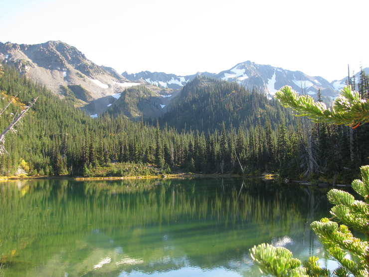
Columbine flowers, Pacific Crest Trail, WA. 2015
-
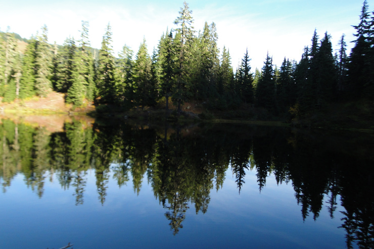
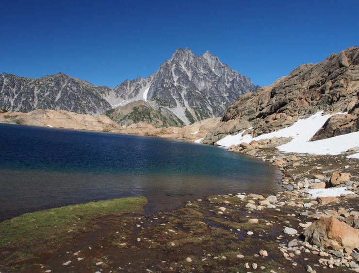
Hope Lake, Pacific Crest Trail, WA. 2015


 25
25


Enjoy being online again!
Welcome to the community of good people who base their values on evidence and appreciate civil discourse - the social network you will enjoy.Create your free account
9 comments
Feel free to reply to any comment by clicking the "Reply" button.The one time I knew I would need a compass...I left it at the Base Lodge at Pinkham Notch. My buddy and I were climbing up Tuckerman Ravine to ski the Headwall and we knew we would be hit with cloud layers. We had hoped to hike all the way to the peak of Mt Washington NH but if it socks in on the the way up or down...you better have a heading to work off of. Sure enough...it socked in when we cleared the Headwall so we changed tactics and followed the rim of Tucks over to the Left Gully and dropped back down to the bowl. Best thing is have a plan...AND a checklist...Dumbass me forgot the checklist. Last time that ever happened. Hikers have gotten lost taking a poop at night. Pick a mag line leading to an area you will have a reasonable chance of privacy and simply reverse the line to get back to the trail. Easy peasy. You can go anywhere in a straight line and back...day or night...rain or snow...and you don't have to worry about declination.
 phoenixone1
Level 8
Jan 12, 2023
1
phoenixone1
Level 8
Jan 12, 2023
1
I assume you mean a mental straight line. Fog, whiteout, cliffs, and burned and blowdown trees, etc. throw you off.
I lost the trail where a wildfire destroyed all vegtation. The trail was covered with ash.
But I knew we should go downhill to get to the creek at the base of the hill. At the creek, turn right and follow it to the cars. Victory!
In 4th grade we were taught geography in school before they called it history or social studies... unfortunately we faced South in my classroom. We were taught basic map reading in class and the top of a map was North, the right was East and the left was West... I have struggled with directions ever since we faced South so a world map was 180 degrees off? I do have mild dyslexia and this is just one example how it affected me... I remember looking out of the classroom window and trying to figure out the compas direction?
 FrostyJim
Level 8
Jan 11, 2023
1
FrostyJim
Level 8
Jan 11, 2023
1
That's understandable. I'm sure you were not alone.
To make directions clear, the teacher should have asked students to stand up and face north. Then point to north, south, east and west.
@LiterateHiker - That is funny because I think she did try having the class turn our desks around for Geography class but it didn't work because the blackboard then was behind us?
I always orientate the map or chart …and myself to True North. The only times that I feel lost are in cities where I get turned around too many times.

One does not get lost. You knew where you were, right there. You were just temporarily geographically embarrassed as you reorientated your location relative to the rest of the world. 
 Cyklone
Level 7
Jan 11, 2023
Cyklone
Level 7
Jan 11, 2023
 2
2
We were too far north. We knew Hope Lake had a wood trail sign.
When I read Des Moines I was trying to figure out why you were in Iowa. And then enlightenment percolated up in my tired brain, there is a Des Moines in Washington state. I've been to both of them.
I am directionally challenged, and left right deficient.. Don't ever tell me north or south, and don't tell me Right or Left (pointing is better). My mother and grandmothers were all L/R confused, it likely has a genetic genetic component. However, one of my kids ALWAYS knows where she is and what direction she is facing. I'm not sure she is truly mine, except she is like my doppelganger. This kid takes her kid on walks through the streets of Utrecht, Netherlands, and always manages to get them home without Google maps. I don't go anywhere without Google Maps, even around town. Google maps tells me and shows me. I am in trouble if I'm ever out and about without Google Maps.
 HippieChick58
Level 9
Jan 11, 2023
1
HippieChick58
Level 9
Jan 11, 2023
1
I'm directional challenged also so I know what you went through. Never really hiked very far into the wilderness. Just not my thing but all the photos you have posted including these are FABulous!
 silverotter11
Level 9
Jan 11, 2023
1
silverotter11
Level 9
Jan 11, 2023
1
Thank you, dear.
Love the story and the flowers. Did you at least get a dip in the lake? 
 Betty
Level 9
Jan 11, 2023
2
Betty
Level 9
Jan 11, 2023
2
With fading light, we didn't tarry.
We used headlamps to steeply descend the last four miles to our cars.
@LiterateHiker Have you ever gone back?
Sure. I've hiked past Hope Lake to higher alpine lakes.
@LiterateHiker The pictures are beautiful.
Thank you, Betty.
Been there, done that! (More than once if I'm honest). It is so easy to set off at 180 to your intended direction!
When I was young, I remember being told a mnemonic for magnetic variation (used to be printed on OS maps with a date and yearly change) "mag to grid, get rid: grid to mag, add"
 Andy4608
Level 7
Jan 11, 2023
2
Andy4608
Level 7
Jan 11, 2023
2

Enjoy being online again!
Welcome to the community of good people who base their values on evidence and appreciate civil discourse - the social network you will enjoy.Create your free account
Share this post
Categories
Agnostic does not evaluate or guarantee the accuracy of any content. Read full disclaimer.