If (like me) you enjoy looking at maps, you might sometimes wonder why a map looks a the way it does. The events leading to a certain demographic being more common here, or a border being drawn there, can often be very complex, and fascinating.
Here I’ve gathered 6 maps of the US state of Alabama. Together, these maps tell a story that links a coastline from the time of the dinosaurs, to modern political demographics, via one of the darkest periods of American history.
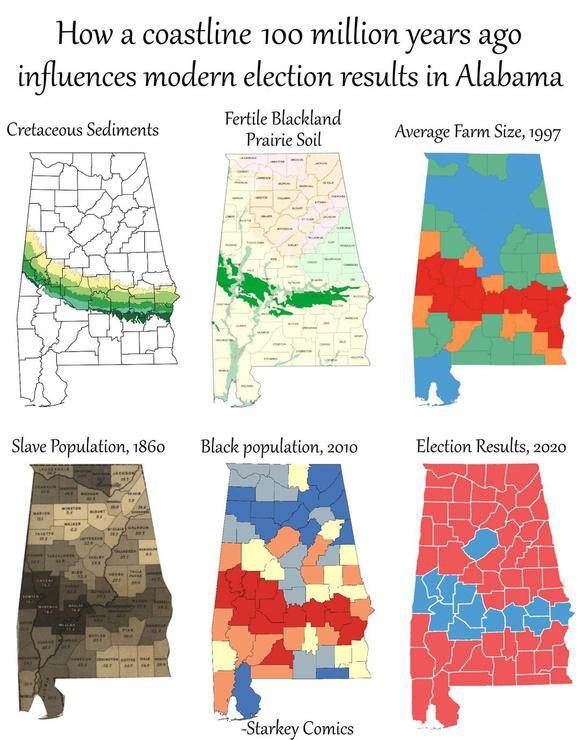
Map 1 shows us the Cretaceous sediments of Alabama. These sediments are rocks and minerals laid down along the swampy southern coast of the continent of Appalachia, which existed around 100 million years ago. North America had not yet formed at this time.
Map 2 shows the location of Blackland Prairie soil. This soil is known for its high fertility, as a result of the nutrients deposited during the Cretaceous period.
Map 3 shows us modern farm sizes in Alabama. The largest farms (shown in red) can be found in areas with the most fertile soil. This shows us how economically important Blackland Prairie soil is.
Map 4 shows slave populations according to the 1860 census. At that time, slaves accounted for 45% of the state’s population. Only 3% of the state population was made up of free Black citizens. In the darkest regions of the map, enslaved people accounted for over 80% of the population. Slaves mainly worked on cotton plantations, and these plantations were most common in the areas with the most fertile soil.
Map 5 shows us the modern Black population of Alabama. The darkest red areas show more than 44% of the population of the region is Black. Despite the 150 years between these maps, these is still a close correlation between the historic slave populations, and the modern Black populations.
And finally map 6 shows us the results of the 2020 election. Areas with large Black populations are much more likely to vote for the Democratic party (shown in blue). This trend continues to the east and west of Alabama, along the so called “Black Belt” of the southern USA, and along the buried coastline of the Cretaceous continent of Appalachia.
When we look at maps and data about the modern world, it’s easy to forget that everything about our world has been dictated and shaped by the events of history, and prehistory. From ancient continents to terrible atrocities, our world is a product of its past, and understanding that past can be key to helping us better understand the present.
-Starkey
Full post here:
[starkeycomics.com]
 2
2


Enjoy being online again!
Welcome to the community of good people who base their values on evidence and appreciate civil discourse - the social network you will enjoy.Create your free account
Recent Visitors 6
PBuck0145
Canada
JonnaBononna
New Orleans,
Redheadedgammy
NM, USA
Julie808
Kapaa, Kauai,
Mitch07102
CA, USA
Photos 1,874 More
Posted by William_MaryBut before we became the victims of state terror, we were accomplices.
Posted by William_MaryFrayedBear just brought my attention to a video that I need to study and do a post on.
Posted by William_MaryA symptom of perception management. The program was completed when the vast amount of the American citizenship became compliant to the delivery of MSM information. [consortiumnews.com]
Posted by KilltheskyfairyIt’s the only way…
Posted by KilltheskyfairyIt’s the only way…
Posted by KilltheskyfairyIt’s the only way…
Posted by HippieChick58Donnie thinks he had every right to interfere with the 2020 election
Posted by KilltheskyfairyHappy Labor Day!
Posted by KilltheskyfairyHappy Labor Day!
Posted by KilltheskyfairyHappy Labor Day!
Posted by KilltheskyfairyHappy Labor Day!
Posted by KilltheskyfairyHappy Labor Day!
Posted by KilltheskyfairyHappy Labor Day!
Posted by KilltheskyfairyHappy Labor Day!
Posted by KilltheskyfairyHappy Labor Day!
Posted by KilltheskyfairyHappy Labor Day!